


The house has been in the house for more than a year, and spring is approaching
No travel, no spring outing, no party,
It was a waste of good mountains, rivers and beautiful scenery!
How to release yourself safely during the epidemic?

It's better to go to the mountains with friends two or three,
Today the team will introduce to everyone
Few people and fun hiking resort,
Standing on an uninhabited mountain and breathing heavily,
Feel the long-lost clean and fresh air!
🚶Basic hiking route🚶
⭐️

on footDistance: about 4 miles
Special recommendation: waterfall with a drop of 40 feet
Trail address: 1750 North Altadena Drive, Pasadena, CA 91107

Eaton Canyon Nature Reserve covers an area of 190 acres. It is a zoology, botany and geological nature reserve. It is located at the bottom of the San Gabriel Mountains. The 40-foot-high waterfall is a good place to take photos~ It’s the season of Los Angeles, everyone can I saw a lot of seasonal streams during the hike, as well as beautiful rocks and minerals~ The presence of mountains and water will definitely make you a worthwhile trip!

However, during the epidemic, you need to make an appointment one day in advance to go hiking in Eton Canyon~ because it is not allowed to make reservations on the same day or walk in directly.Of course, tickets are free here.The reservation is to prevent the Eaton Canyon Trail from becoming overcrowded. You need to provide proof of booking and photo ID before entering the trail.
Reservation website:
https://www.ecnca.org/


on footDistance: 4.1 miles
Special recommendation: invincible sea view
Trail address: 21601 Pacific Coast Hwy. Huntington Beach. CA 92646

Huntington Beach’s trail is more like a seaside walk. This simple and flat coastal trail is very suitable for those who like to enjoy walking slowly~

And Huntington Beach is a beach where dogs are allowed to play.Walking along the coastline with your dog to enjoy the sea breeze and sunset, why hesitate?Let's go on the rest day!

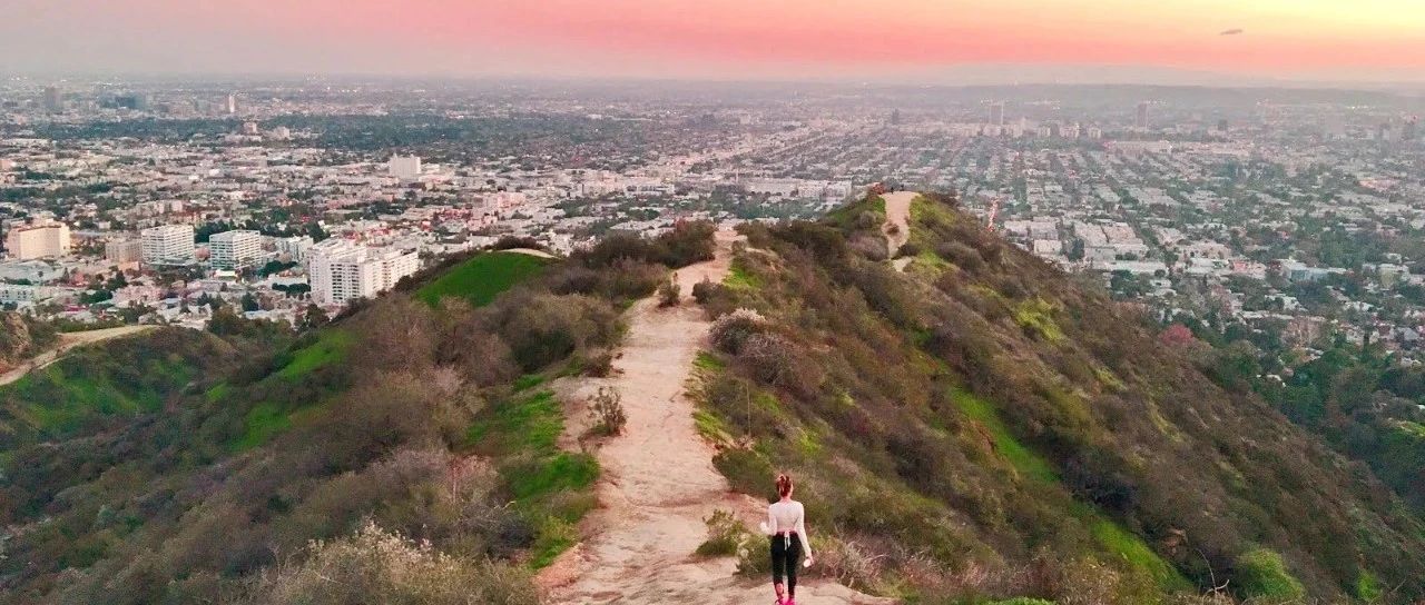
on footDistance: 2.7 miles
Special recommendation: City panorama of Los Angeles
Trail address: Runyon Canyon Rd, Los Angeles, CA 90046

Standing on the top of the hill, you can see the skyline of Los Angeles on the edge of the city, the mansions on Sunset Boulevard and the stunning scenery of the Los Angeles Basin.If the weather is good, you can still see the Hollywood sign and the sea.For beginner hikers who just want to see the scenery, this route has to be walked again.

However, during the epidemic, the East Trail was temporarily closed, and now only the West Trail Loop is a one-way loop from south to north.

on footDistance: about 1.5-2.5 miles
Special recommendation: the pristine natural scenery of the forest
Trail address: Lake Drive & Franklin Canyon Drive, Franklin Canyon Park, CA 90210

This trail in Franklin Canyon Park is a good hiking place worth exploring. There are many sights to see here. Franklin Canyon Park covers a total of 605 acres and has more than 5 miles of hiking trails.Take a relaxing stroll around the reservoir, and you can see groups of ducks and turtles~

Of course, there are many more difficult Hiking trails, such as the Hastain Trail, which is 2.3 miles long. Hiking along a very steep landslide, you can see the scenery extending from West Los Angeles to the Pacific Ocean!Friends who want to challenge can try it~

on footDistance: about 7.2 miles
Special recommendation: overlooking the bay
Trail address: 510 Los Liones Dr, Pacific Palisades, CA 90272

The recent good cold weather is perfect for hiking on this trail. There are lush canyons and it is only one mile from the Pacific Ocean.Hiking to the summit, looking out from the 1525-foot peak, you can see the magnificent San Bernardino Mountains and the sparkling Santa Monica Bay in the sun.

But the whole journey is more than 7 steps, although the road is very easy to walk, but it is still a bit tired to walk the whole journey!Get up while the temperature is not high~ Remember to bring a kettle~
🚶Intermediate hiking route🚶
⭐️ ⭐️ ⭐️

on footDistance: 1.25 miles
Special recommendation: 360° city view
Trail address: 6300 Hetzler Rd. Culver City. CA 90232

How can a trail of less than 2 steps be in the intermediate route?There are 282 steps on this hiking route, and one back and forth is enough to make everyone's legs tremble!And the stairs here are really super high!One of the best~

I want to finish it in one breath, it is to test everyone's usual aerobic training results~ But when you reach the top of the mountain, you can see Santa Monica Bay, Hollywood Hills, downtown Los Angeles, and even the San Gabriel Mountains.It feels like standing at the top of the entire Los Angeles center, with a panoramic view of the Pacific Ocean.

on footDistance: about 4 miles
Special recommendation: potato chip rock
Trail address: Mount Woodson Trail, Poway, CA 92064

The trail where Potato Chip Rocks is located is on the way from Los Angeles to San Diego. It is a one-way 4-mile hiking route from Lake Poway. Although you can overlook Lake Poway along the way, the scenery is also good, but if you go in summer, most of the distance is really sunny. It takes four hours to go back and forth.

The two-hour mountain road has no special scenery. There are large and small rocks along the way. The road is also a dirt road. It is not recommended that you wear expensive shoes and light-colored shoes.But after you reach the end, take a group of creative photos on the thin potato chip rocks. One of the nine thrilling places in the world will make you feel tired and worth it!

on footDistance: about 15 miles
Special recommendation: the once tribal land of the Indians
Trail address: Malibu Creek State Park, Calabasas, CA 91301

This great place for hiking is only 25 miles away from the noisy DTLA. This paradise has creek trails, volcanic lava more than XNUMX million years ago, and beautiful quiet small ponds.

Because of the lush forest, there are many wild animals here!You may see bobcats, coyotes, deer, eagles, owls, and egrets.In this beautiful jungle with few people, everyone can swim, picnic, rock climbing, bike, camp, and embrace nature.
🚶Advanced hiking route🚶
⭐️ ⭐️ ⭐️ ⭐️ ⭐️

on footDistance: about 10.1 miles
Special recommendation: adventure journey of trekking and wading
Trail address: Sheep Mountain At East Fork Rd, Azusa, CA 91702

If you want to explore, you must walk Bridge to Nowhere once.The "signature" bridge on this trail was built in 1930, but was later abandoned due to the impact of flash floods.I want to finish this 10-foot trail, but I need to use both hands and feet to climb up and down, and I have to cross several streams and rivers to complete the task!

Especially in winter, the water is really cold and the water level is high. Hiking is definitely a harsh challenge at this time!Before you go, everyone has to buy an adventure pass for $5. Remember to put it on the front windshield of the car when you reach the destination.Remember to wear wading + climbing equipment, change clothes, and bring hiking sticks.
Purchase URL:
https://www.rei.com/product/810590/southern-california-daily-forest-adventure-pass

on footDistance: about 4 miles
Special recommendation: climb to the top of the double-layer waterfall
Trail address: Escondido Canyon Trail, Malibu, CA 90265

Escondido Falls is the highest waterfall in the Santa Monica Mountains. Every weekend, many hikers will challenge this 3.8-mile hiking route.It started with an uphill road, then a dirt road, and finally reached below the waterfall.Sounds easy, right?

But in fact, the real challenge starts with the trail of only 150 feet at the end: because it is slippery and steep, you need to climb rocks or step on tree roots to reach the top of the waterfall.But standing at the top of the beautiful double-layer waterfall, you will definitely feel that your hard work is worth it~ Climbing the top of the waterfall here will have a great view~

on footDistance: about 11.3 miles
Special recommendation: Thrilling snow mountain hike
Trail address: Mt Baldy, CA 91759

Mt. Baldy is the highest peak in the San Gabriel mountains in the Los Angeles area, with an elevation of 10064 feet, and is also the highest mountain in the greater Los Angeles area.If you want to have an adventure full of snow hiking in winter, here is the best choice.

In winter, you must have enough equipment to climb the snow mountain. If the weather is good, you can see the Pacific Ocean and the Mojave Desert from the mountain!It’s also good to go out in spring. In spring, you can see wild flowers all over the mountains, chipmunks, bighorn sheep, black bears and other animals.There are several hiking trails leading to the top of Mt Baldy, and challenging trails here may require the use of more advanced climbing equipment and techniques.
Tips

-Be sure to check the strategy before traveling;
-Be sure to go with your friends;
-Be good at sun protection in spring, summer, autumn and winter, bring enough water, and replenish water in time;
-You can bring some energy bars and supplies;
-Wear suitable hiking and hiking clothes and shoes;
-During the epidemic period, you must take good care of yourself, wear masks in time when encountering people, pay attention to safe social distance, and do disinfection protection.
Finally, everyone had fun~
Go to the wild to breathe fresh air,
Be sure to pay attention to safety too!
💪

Author | Tuantuan face
Pictures | Partly from the web,
Copyright belongs to the original author
Typography |